Tokyo, September 02, 2014
Fujitsu announces that it has built a computer system for the Global Precipitation Measurement (GPM) mission being undertaken by the Japan Aerospace Exploration Agency (JAXA), in collaboration with NASA(1) and other international government agencies. The Fujitsu-built computer system, the GPM/DPR (Dual-frequency Precipitation Radar) Mission Operations System, serves as one of the central ground systems of the GPM mission.
The system gathers data from multiple satellites, including the GPM Core Observatory(2), which was launched on February 28, 2014, generating precipitation (rainfall and snowfall) data around the world and distributing it to organizations, including NASA, the Japan Meteorological Agency, the International Centre for Water Hazard and Risk Management (ICHARM), and the Infrastructure Development Institute (IDI).
The system is connected to the NASA's Precipitation Processing System in Maryland, and for some Near Real Time processing operations, it is required to receive data from NASA, process it, and return it in only 13 minutes. To accomplish this, Fujitsu constructed a dedicated system to do the rapid processing. To ensure that data is continually being received, processed, and transmitted correctly 24×7, the system needs to be reliable, and for that reason it uses Fujitsu's own middleware products. Fujitsu has provided a comprehensive system, from the platform to applications to operations and maintenance.
When the system went online on February 28, 2014, JAXA distributed data from the system to a limited number of institutions, and, as of today, it begins providing publicly available online data from G-Portal, its system for providing global monitoring satellite data.
The GPM mission is an international project that aims to improve understanding of the mechanisms underlying the planet's hydrological cycle, contribute to water-resource management, and raise the accuracy of weather forecasts.
The GPM Core Observatory and a constellation of other supporting satellites take multiple observations of global precipitation each day, enabling observation of the status of precipitation in areas where few observations have been taken in the past, such as the oceans.
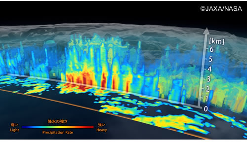
 3D image of precipitation distribution based on DPR data aboard the GPM.
Role of the GPM/DPR Mission Operations System
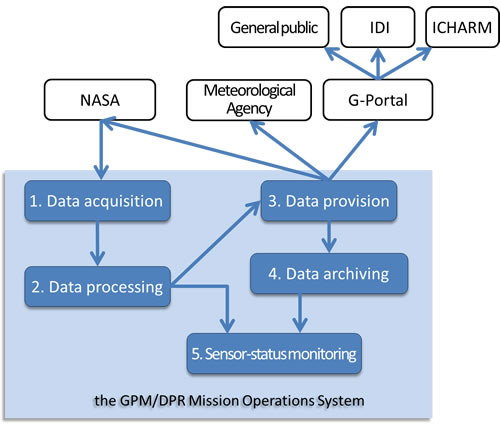
The system receives observational data continually, 24×7, from the GPM Core Observatory and supporting satellites via NASA's Precipitation Processing System, generates global precipitation data, including a 3D distribution of precipitation intensity, and distributes that data to organizations, including NASA, the Japan Meteorological Agency, ICHARM, and the IDI.
Overview of the GPM/DPR Mission Operations System
- Data acquisition
Observational data from the GPM Core Observatory and supporting satellites, satellite orbit and attitude information, and other data are acquired from NASA's Precipitation Processing System.
- Data processing(3)
The system analyzes the acquired data and generates global precipitation data, including a 3D distribution of precipitation intensity.
- Data provision
The generated data is provided directly from the system to NASA and the Japan Meteorological Agency. The data is made available online via JAXA's G-Portal to ICHARM, IDI, and the public users.
- Data archiving
All of the data created in the system is stored in compressed form for a fixed period. It is managed in a catalog, so that a desired piece of data can be searched for and retrieved.
- Sensor-status monitoring
To monitor the status of the Dual-frequency Precipitation Radar (DPR), a sensor on board the GPM satellite that measures precipitation, the system creates time-series graphs of voltage, current, and other information.
 System Overview of the GPM/DPR Mission Operations System
Features of the GPM/DPR Mission Operations System
- Designed for high-speed processing
The system is connected to NASA's Precipitation Processing System (PPS) in Maryland, and in some cases, it receives data from NASA, processes it, and returns results in as little as 13 minutes. To accomplish this, Fujitsu constructed a dedicated system to do the rapid-processing. Fujitsu also chose to use a storage-area network (SAN) to share files among servers, which further shortens data-transmission times within the system.
- Flexibility to accommodate additional supporting satellites
For this system, a versatile control program was prepared that can universally accommodate a processing flow sequence, regardless of the type of satellite, along with a specific data processing program for each individual satellite. The system also offers a method whereby parameters can be set to define the dependency relationship of the data processing programs that are within the data flows, as well as the relationships between input-output data.
As a result, when a new supporting satellite is added, it is now possible to easily add a data processing program just by changing the parameter settings.
- Organized to easily make continuous improvements to data-processing algorithms
JAXA plans to make ongoing improvements to its data-processing algorithms thereby making progress on the study of global precipitation.
The system can experimentally run an upgraded processing program using a part of the full operations environment. This allows JAXA to test these upgraded programs without the extra effort of setting up a separate test environment, so that the improvement process can be faster.
- Reliability
The system uses FUJITSU Software Systemwalker for integrated operations management, FUJITSU Software PRIMECLUSTER as the high-reliability platform software, and FUJITSU Software Interstage as the business-application platform, all of which work together for high overall system reliability, availability, and performance. They also ensure good flexibility for autonomous operation and scalability. The servers and networking equipment that make up the system include redundancies, with quick switchover to backup hardware in the unlikely event of a failure, so that operations continue without interruption.
Comment from Toshiaki Takeshima, Director, Mission Operations System Office, Satellite Applications Mission Directorate I, Japan Aerospace Exploration Agency (JAXA)
"The GPM project, a joint mission with NASA, involves cooperation among many partners, through which we use data from a constellation satellites, in addition to the GPM Core Observatory. In the process to develop the GPM ground system, we encountered quite a few issues. However, thanks to the support from the GPM satellite project team and all the involved parties, we were able to work through every problem and uncertainty one by one. In the near future I hope to see a wide range of users take advantage of the GPM data processed by this system, and then put to use in improved weather-forecasting systems, the mitigation of damage caused by floods, typhoons and other natural disasters, and a deeper understanding of the mechanisms that underly climate change and extreme weather."

