![]()
Archived content
NOTE: this is an archived page and the content is likely to be out of date.
Fujitsu Uses Image Analysis Technology to Generate Rice Paddy Parcel Maps from Satellite Images and Aerial Photos
Field testing aimed at streamlining operations at agricultural mutual aid associations to commence
Fujitsu Limited
Fujitsu today announced that, in collaboration with the Federation of Hokkaido Agricultural Mutual Aid Association (Hokkaido NOSAI) and the Kamikawa Chuo Agricultural Mutual Aid Association (Kamikawa Chuo NOSAI), it will aid in creating maps of rice paddy parcels using proprietary Fujitsu image analysis technology. The technology will utilize satellite images and aerial photographs to recognize the boundaries between rice paddies and the embankments that separate them. From August 9 to October 31, Fujitsu will be conducting a field test to evaluate the technology's usefulness in confirming the crop area of new members when they join NOSAI, as well as other applications.
Background
Since agriculture depends heavily on natural conditions, Japan's agricultural mutual aid system(1) helps provide relief to farmers by compensating them based on the area of the land and the type of crops they are cultivating when fields are damaged by typhoons, severe rainfall or other natural disasters. In order to operate, each year federations of agricultural mutual aid associations throughout Japan (NOSAI) are required to quickly identify newly added farmland and crop rotations by working with member farms and affiliated organizations to check each of a vast number of rice paddies and manually update rice paddy parcel maps. This is usually performed based on farmer-submitted crop change reports that provide information about farmland that has been converted from rice paddies to another kind of crop, and vice versa. At the same time, due to Japan's aging farmer population and a lack of new farmers, these activities represent a substantial workload for member farmers, while also presenting a significant burden to NOSAI, in terms of both labor and cost. To preserve Japan's agricultural mutual aid system, streamlining the process of updating agricultural parcel maps is a significant priority, and NOSAI is actively engaged in efforts to improve agricultural parcel mapping through the use of Geographic Information System(2) technology.
Overview of the Field Testing
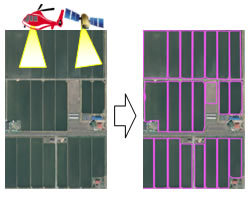 Extracting rice paddy parcels from images of farmland
Fujitsu is currently engaged in efforts to leverage its ICT in upgrading and improving the efficiency of environmentally friendly farming practices. Beginning this January, the company explored how it could leverage its technology, together with technology from Hokkaido NOSAI, to produce agricultural parcel maps and to improve operational efficiency through the use of these maps.
As part of the field testing, Fujitsu will employ its proprietary high-precision image analysis technology, which brings together filtering processing for highlighting the contours of an image with an edge extraction technique that can recognize essential shape features. This enables images captured by satellites or aircraft to be used for recognizing boundaries between rice paddies and the embankments that separate them. The resulting data can then be used to automatically produce maps of rice paddy parcels. Going forward, by comparing the new maps to rice paddy parcel maps that have been produced by hand, Fujitsu will examine the usefulness of this technology in the operations of agricultural mutual aid associations.
1. Testing period: August 9, 2012 to October 31, 2012 (2 month period)
2. Locations: Takasu, Kamikawa-gun, Hokkaido and Higashi Takasu, Asahikawa-shi, Hokkaido
3. Overview:
(1) Automatically analyzing satellite images and aerial photographs, generating maps of rice paddy parcels (Figure on the right)
(2) Comparing the accuracy of rice paddy parcel maps generated through image analysis with manually created maps based on on-site observation
(3) Studying the results of the comparison, examining the applicability of the technology for improving the efficiency of on-site observation work
Future Development
Based on the results of the field test, Fujitsu will aim to develop a commercial service for generating rice paddy parcel maps using its image analysis technology by April 2013. The company will also investigate new applications for the technology, including support for other kinds of farmland parcel mapping beyond rice paddies, as well as applications in areas outside of agricultural mutual aid associations, such as for discovering abandoned arable farmland. Moreover, Fujitsu is working to extend the use of the technology to a wide range of areas and tasks, such as for discovering ways to improve land use efficiency in urban areas.
-
[1] Agricultural mutual aid system
A system intended to create stability in farm management by compensating farmers for losses incurred as a result of natural disasters. Based on Japan's Agricultural Disaster Compensation Act, the system serves as a countermeasure against damage from natural disasters for Japan's farmers. Each region in Japan is served by its own NOSAI group. Kamikawa Chuo NOSAI, the agricultural mutual aid association for farmers of one city and eight towns in Asahikawa-shi, Hokkaido, and Hokkaido NOSAI, which insures all mutual aid associations located in Hokkaido, are working in collaboration with Fujitsu in this field test.
-
[2] Geographic Information System (GIS)
A system that uses geographic positioning to comprehensively manage, process, and visually display data containing information relating to a particular location. The system is able to perform sophisticated analyses and rapid decision-making.
About Fujitsu
Fujitsu is the leading Japanese information and communication technology (ICT) company offering a full range of technology products, solutions and services. Over 170,000 Fujitsu people support customers in more than 100 countries. We use our experience and the power of ICT to shape the future of society with our customers. Fujitsu Limited (TSE:6702) reported consolidated revenues of 4.5 trillion yen (US$54 billion) for the fiscal year ended March 31, 2012. For more information, please see http://www.fujitsu.com.
All company or product names mentioned herein are trademarks or registered trademarks of their respective owners. Information provided in this press release is accurate at time of publication and is subject to change without advance notice.
Date: 17 August, 2012
City: Tokyo
Company:
Fujitsu Limited,
,
,
,
,
,
,
,
,
,